Technology Innovator Interviews: Taking Environmental Monitoring to New Heights
This week, we are diving deep into geospatial technologies with Jeff Allenby of the Center for Geospatial Solutions (CGS) and Allegra Wrocklage of Upstream Tech. This topic is particularly near to me, as I previously worked for Upstream Tech for several years exploring ways to make satellite data more accessible to conservation organizations. This experience motivated my work on Digital Service for the Planet to ensure that federal agencies can utilize the best and most up-to-date environmental information to guide their natural resource planning and long-term stewardship of vast landscapes.
Recognizing the importance of making geospatial technology accessible to those without technical training or expertise, Upstream Tech and CGS recently formed a partnership to offer a suite of geospatial services to land trusts and conservation organizations. In this blog, they’ll explore examples of how sophisticated mapping technologies can be used to speed up and scale conservation efforts. They’ll also discuss opportunities to remove barriers for agencies to be a better buyer, partner, and consumer of the data and technological innovations needed to meet stewardship goals.
Let’s get to it!
QUESTIONS & ANSWERS
For starters, what were some of the key components of the Digital Service for the Planet that resonated with your team?
Jeff: Our team brings together pioneers and leaders from across the conservation, technology, community engagement, and international development fields to forge a new vision for the role that technology can play in meeting global conservation goals and effectively managing conserved landscapes. We are working to build solutions that meet the needs of individuals working at the ground level that also scale and provide efficiencies and consistency to a challenging global effort of managing conservation data across hundreds of countries and tens of thousands of partners.
We see clear opportunities for technology solutions that have transformed other industries to be adapted to meet the challenges outlined in the Biden Administration’s America the Beautiful initiative to protect 30% of U.S. land by 2030. We are excited to partner with other technology companies in the Digital Service for the Planet coalition.
Allegra: At Upstream Tech, we believe that geospatial technology can play a crucial role in helping the Biden administration meet its initiative. In particular, the prevalence of satellite imagery and data offers new insights for government agencies to better target their conservation work. In developing our Lens web app, our goal was to make an easy-to-use remote monitoring tool that provides access to a wealth of satellite imagery and environmental data, without requiring a high level of technological or geospatial expertise to use.
Through our work with federal and state agencies, we’ve seen how government staff have taken advantage of technologies like Lens to access consistent and up-to-date satellite imagery and data. This provides them new opportunities to collaboratively manage landscapes and better understand how they are changing over time.
We are excited to join the Digital Service for the Planet coalition to explore how environmental technologies can help accelerate agencies’ conservation and landscape management work.

The Rio Grande River winds through New Mexico, displayed in Upstream Tech Lens. (Lens basemap, copyright Mapbox.)
What are the benefits of making environmental technologies more accessible and easy to use?
Jeff: Over the last five years we have seen incredible advances in the environmental technology field as high resolution satellite imagery has become more accessible, “big-data” analysis became available as a cloud-resource, and web-based GIS tools are approaching the capabilities of traditional desktop analyses. The simultaneous development of these three capabilities has unlocked insights into the landscape that were once reserved for high level tasks or only small areas of interest, and are now available to anyone, anywhere.
This unprecedented access to insights about where to work and what to do is leading to managers expanding their understanding of underlying challenges and opportunities through a data-driven approach. We are seeing partners find opportunities that may have otherwise been missed, but we’re also seeing that access to these capabilities is resulting in better outcomes, more effective communication of why action is needed, and increased staff efficiency. These tools are also making it easier for agencies to create baselines for landscapes, to understand change over time, and to share data and priorities with each other as well as with non-governmental partners to build a common understanding of priorities across the landscape.
Allegra: Federal agencies collectively manage hundreds of millions of acres, yet government staff cannot consistently or safely visit every acre of it in-person throughout the year. Geospatial technologies offer government staff new tools - beyond just boots-on-the-ground visits - to efficiently and effectively manage and gain insights on these vast landscapes.
For example, the Forest Service uses our Lens app to assess the outcomes of long-term, large-scale restoration projects in Arizona and New Mexico. Under business as usual, Forest Service staff would likely only be able to assess progress on their work by visiting project locations in-person once a year or so. On these visits, they would be further limited to gathering data in locations they could access on foot over a couple of hours. Such constraints make it incredibly difficult to get a full and clear picture of the outcomes of their extensive restoration work, in this case tracking seeding regrowth on the site of wildfire that burned over 1,500 acres of hilly terrain and monitoring the effects on vegetation of excluding grazing cattle from a remote riparian area.
Lens provides the team an entirely new approach. Rather than relying solely on infrequent, in-person data collection, staff easily accessed a range of satellite data through Lens to track vegetation growth on their projects over a five year period. Because Lens aggregates satellite data from multiple providers into an easy-to-use online platform, even staff without strong GIS or geospatial backgrounds were able to analyze the information to understand the outcomes of their restoration work. They can use this knowledge to adaptively manage projects as the need arises.
As climate change impacts our landscapes in unexpected ways, the efficiencies offered by accessible geospatial technologies need to become the new standard for environmental agencies. Further, given perennially limited budgets, technologies like Lens can help government staff better understand and replicate successful work.
Where is the low hanging fruit for environmental tech adoption in government agencies that offers the greatest benefits or efficiencies?
Jeff: Across federal agencies, there is a wealth of information about the landscape’s current condition and how it has changed over time. However, it is often trapped within complex databases, or paper files stored in an office, which makes them largely inaccessible to other agencies and the general public. Simultaneously, agency staff are spending tremendous amounts of time on data creation and analyses due to manual or outdated methods.
Adopting digital tools for data collection alone has the potential to save hundreds of thousands of hours of staff time across the federal government while also reducing the amount of data cleaning that is required later in the process due to mis-entered or inconsistent data. Similarly, empowering non-technical staff with access to key information through web-maps and dashboards can transform how an agency operates by creating real-time intelligence and insights into agency operations and priorities. In most cases, adopting these technologies will not require additional investments in new software, but it will take policy changes and setting up new protocols.
Creating modern, digital-first workflows that take advantage of these new capabilities will help create standardized, machine-readable data; increase staff efficiency on tasks from field data collection to data analysis; and facilitate the consolidation and sharing of information across agencies and outside organizations.
Allegra: As compared to relying solely on written records, an online interface for property record keeping would provide government staff easier access to satellite imagery and data to better inform their management. The Maryland Environmental Trust, a division of the Maryland Department of Natural Resources, uses our Lens app to track the locations of inadequate forested buffers near rivers on their conservation properties. These forested buffers are critical for managing water pollution, as the vegetation prevents streambank erosion and traps fertilizer runoff from agricultural fields.
Typically, monitoring the size of these buffers requires that the department’s stewardship staff spend hours walking the perimeter of a single property. With Lens, those same staff use an easily-accessible portfolio of satellite data to monitor the buffers on all of their riverfront properties in an afternoon, plus target where interventions are needed. They also refer back to historic imagery to identify when and how a landowner might have reduced a riparian buffer (for example, by increasing the size of an agricultural field).
The ease with which environmental data can be managed in online platforms further opens up new opportunities for it to be shared between agencies to improve outcomes. For instance, Maryland Environmental Trust’s online data on forested buffers could be shared with public health agencies responsible for protecting drinking water, to help them understand how and where vegetation restoration might boost water quality.
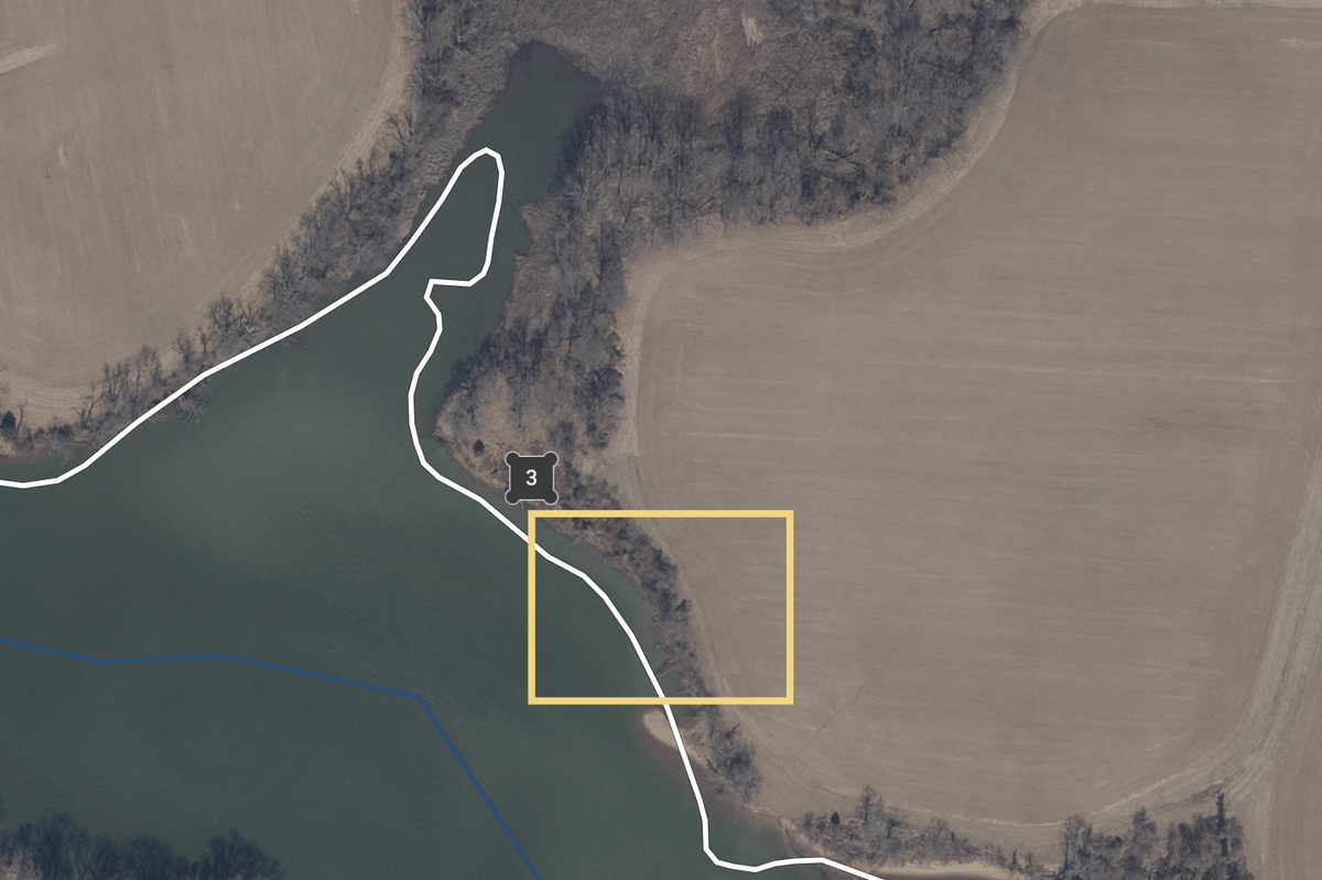
Satellite imagery in Upstream Tech’s Lens, in which Maryland Environmental Trust staff highlight where a forested buffer is too thin on the edge of an agricultural field. (Includes copyrighted material 2019 Upstream Tech and Maryland Environmental Trust. All rights reserved.)
Based on your work or experience with government agencies, what are the challenges for larger scale adoption of conservation technologies by the government?
Jeff: One opportunity we see in working with the government is ensuring federal agencies can integrate existing environmental technology into their work rather than having to reinvent the wheel by building their own tools. Federal agencies already have access to much of the software and hardware needed to create an interconnected and accessible system. However, federal government partners will have to think differently about system architecture and expand out of existing patterns of using solely the systems and methods agencies have invested in over the years.
There is an opportunity for agencies to consider new technologies that might be a better fit for their needs and, if a better alternative is found, to foster a willingness to depart from their current technology if new functionality cannot be integrated into existing systems. While we have seen success working with semi-customized commercial off the shelf software, many agency partners are still in a mindset of needing to create fully-customized solutions to get the functionality they need.
Allegra: At Upstream Tech we’ve had great experiences working with federal and state agencies to pilot Lens, with a shared goal of learning how the adoption of new technologies can enhance collaboration across teams and scale up conservation work. These engagements have taught us about the specific needs of individual agencies, which helps us shape our product roadmap to better support them and build trust for using new technologies.
Through the Digital Service for the Planet coalition we hope to raise awareness of existing and accessible environmental technologies that align well with the needs of government agencies. We think pilots that are explicitly aimed at rapidly testing new technologies - with an eye toward scale - are a great strategy to support government agencies as they explore new ways of doing work.
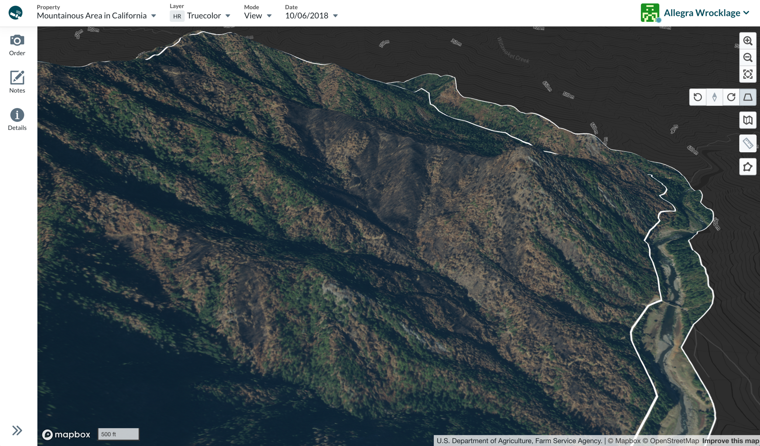

Satellite imagery in Upstream Tech’s Lens shows two images of the same area where vegetation on a mountain slope was burned by a wildfire. The right image displays Lens’ vegetation layer, where white and orange areas indicate lower photosynthetic activity. This helps users identify where the wildfire impacted vegetation. (Includes copyrighted material 2018 Upstream Tech and USDA National Agricultural Imagery Program. All rights reserved.)
As climate change increases the severity and frequency of wildfires, floods, and other natural disasters, so too rise the costs of managing our natural landscapes. Easy-to-use geospatial tools give government staff a landscape-level view of the natural resources they manage. They also provide the granularity to spot where a forest may be particularly vulnerable to fire, or determine where conservation practices on farm fields could help reduce fertilizer runoff into a city’s drinking water. The ability for all government staff - regardless of technical expertise - to quickly and easily access satellite imagery means they can more efficiently and proactively make necessary interventions.
Luckily, advances in geospatial technologies and increases in data availability and integration capability have made these crucial tools easier to use and increasingly affordable. A Digital Service for the Planet would create the institutional capacity for environmental agencies to utilize these technologies to meet environmental management goals for cheaper. This new way of doing business for federal agencies will bring our natural resource management into the 21st century, protecting our environment, improving human health, and staving off the threats of climate change.
### About these organizations
Upstream Tech
Upstream Tech is a mission-driven technology company. Our Lens web-based application gives organizations access to the best-available satellite, aerial, and environmental data to efficiently remotely monitor conservation properties, no matter how large or remote. Land trusts, project developers, government agencies, and conservation organizations collectively use Lens to monitor over ten million acres of land across the United States and beyond.
The Center for Geospatial Solutions
The Center for Geospatial Solutions was created at the Lincoln Institute of Land Policy to advance the use of geospatial technology in the environmental sector and offer inclusive access to these powerful tools and technologies. We partner with diverse organizations and individuals that seek equitable solutions to climate change, habitat loss, water scarcity, and other challenges that threaten the quality of life for all people.